Technical Report – Nov 7, 2012
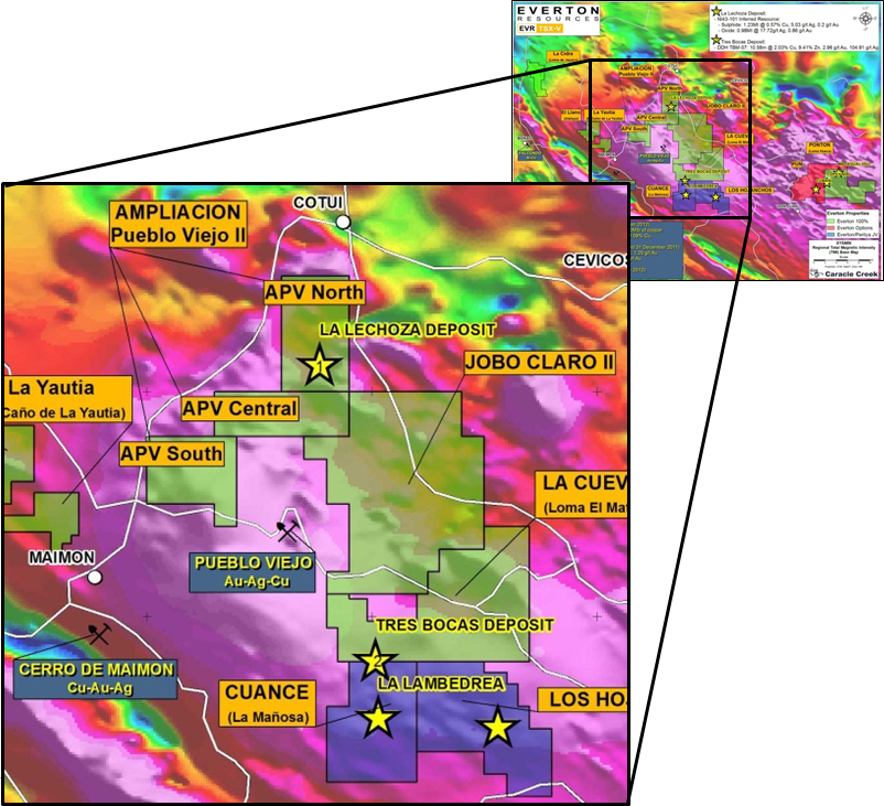
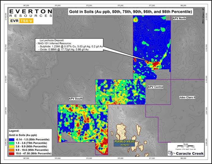
The Cabirma Del Cerro (formerly Ampliacion Pueblo Viejo) Concession consists of 4,045 hectares adjacent to the northern edge of Barrick/Goldcorp’s 29 million ounce Pueblo Viejo mine. Recent trench work by Linear Gold has encountered significant mineralization grading 11.3 g/t gold and 310 g/t silver over 18 meters.
January 27 2011
Query3 (gray) LZ holes (historical RC by Rosario Dominicana 1980´s)
Query4 (green) LL holes (DDH by MIM in 2002)
Query5 (yellow) LE holes (DDH by Linear in 2003/2004)
Query6 (cyan) APV09 holes (DDH by EVR in 2009)
Query7 ((blue) APV10 holes (DDH by EVR in 2010)
Query8 (red) APV11 holes (DDH by EVR in 2011, in progress)
Query9 (open circles) proposed DDH holes in the immediate future 2011 by EVR
February 25 2010
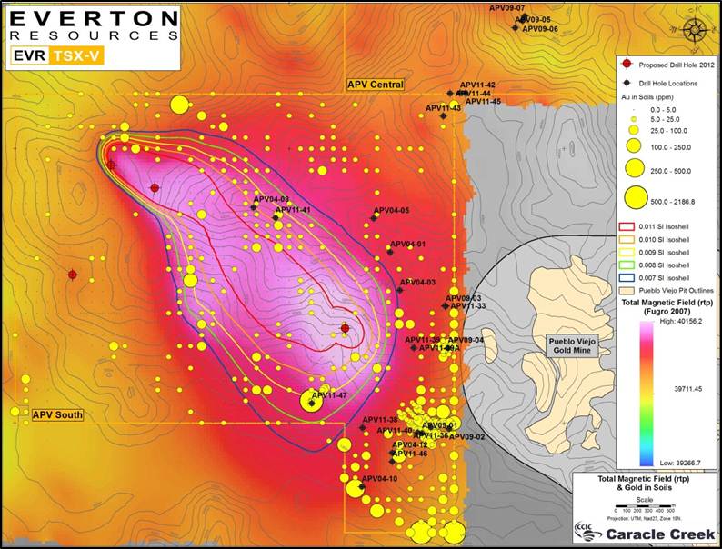
In 1981, the government mining company, Rosario Dominicana intersected 12.3 g/t gold over 12 meters during a shallow drill program. A drilling program conducted in 2006 by Barrick/Goldcorp at the Pueblo Viejo Mine outlined new mineralized trends that define a NNW corridor. Drill intercepts of 2.98 g/t gold over 117.7 meters (hole DPV06-04), 10.18 g/t gold over 9.87 meters (hole DPV06-12), 3.0 g/t gold over 108.4 meters (hole DPV06-03), and 5.31 g/t gold over 23.5 meters (hole DPV06-06) were cut in the extensions of the pits at Pueblo Viejo (Barrick presentation, NRSA, April 2-3, 2007). Gold-in-soil anomalies from a test line located on the Ampliacion Pueblo Viejo concession north of the Pueblo Viejo mine suggests that the new mineralized trend found by Barrick/Goldcorp may extend onto the Ampliacion Pueblo Viejo concession.
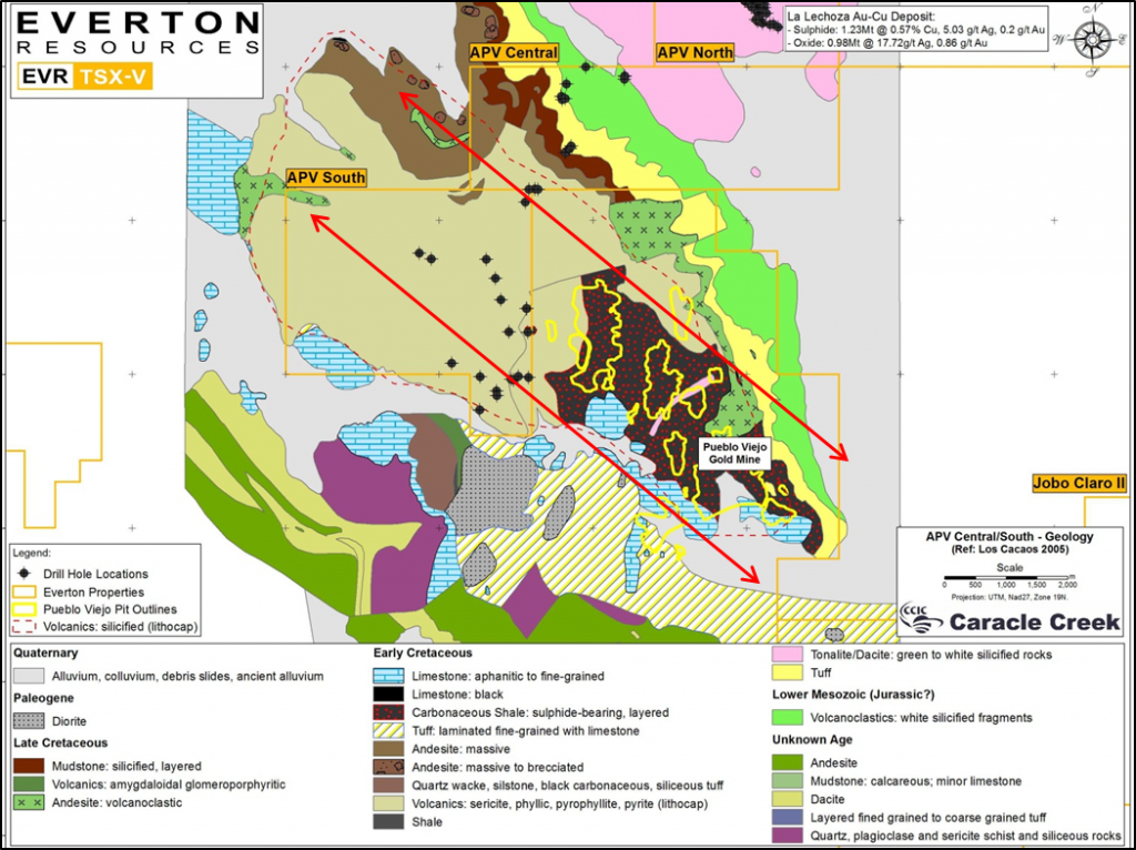
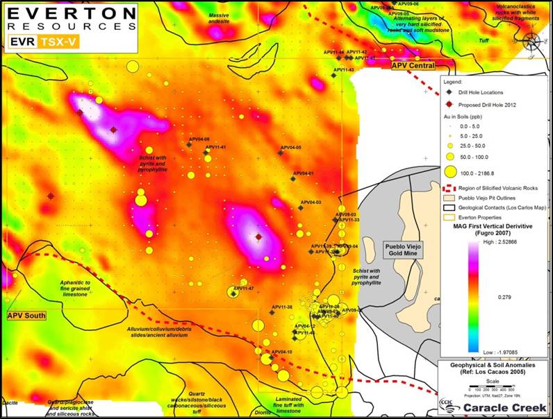
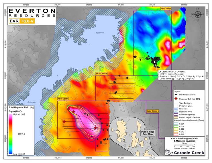
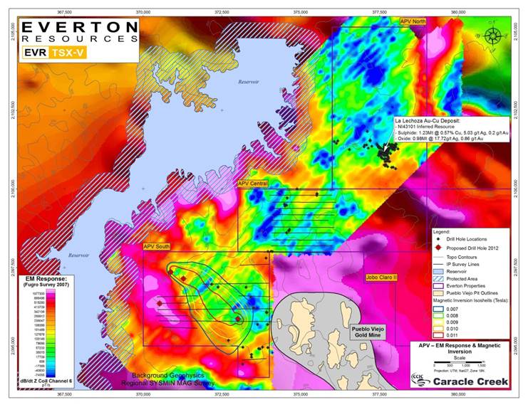
The Ampliacion Pueblo Viejo concession covers a portion of the entire stratigraphy of the Los Ranchos Formation, including shallow marine/lacustrine carbonaceous sandstone and shales, which hosts the Pueblo Viejo mine. The Los Ranchos Formation is overlain by the more recent Hatillo Limestone. A recent study by Sillitoe et al. (2006) reports that the basal contact of the Hatillo limestone with the Los Ranchos carbonaceous units shows clear evidence of hydrothermal activity characterized by extensive advanced argillic and alteration. The inference is that the Hatillo limestone may have acted as an impermeable lithocap and thus having a decisive factor in the creation and preservation of the Pueblo Viejo deposit.
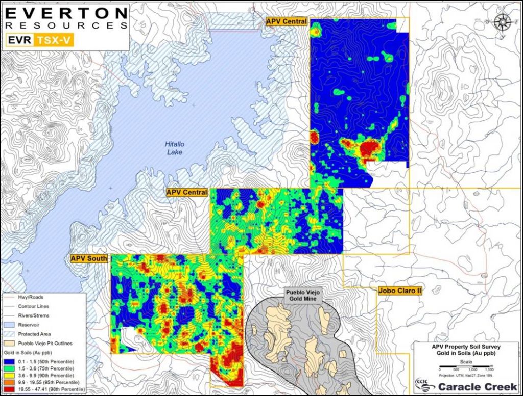
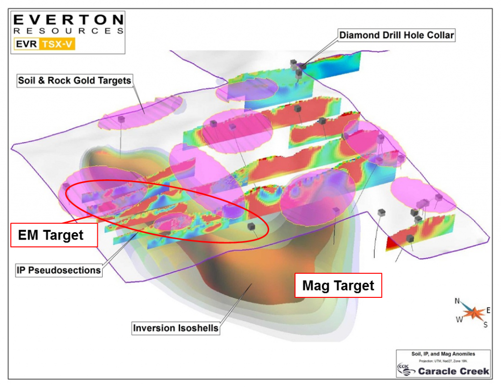
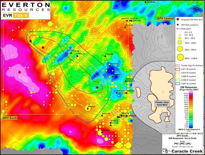
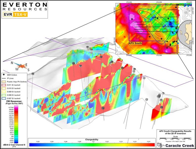
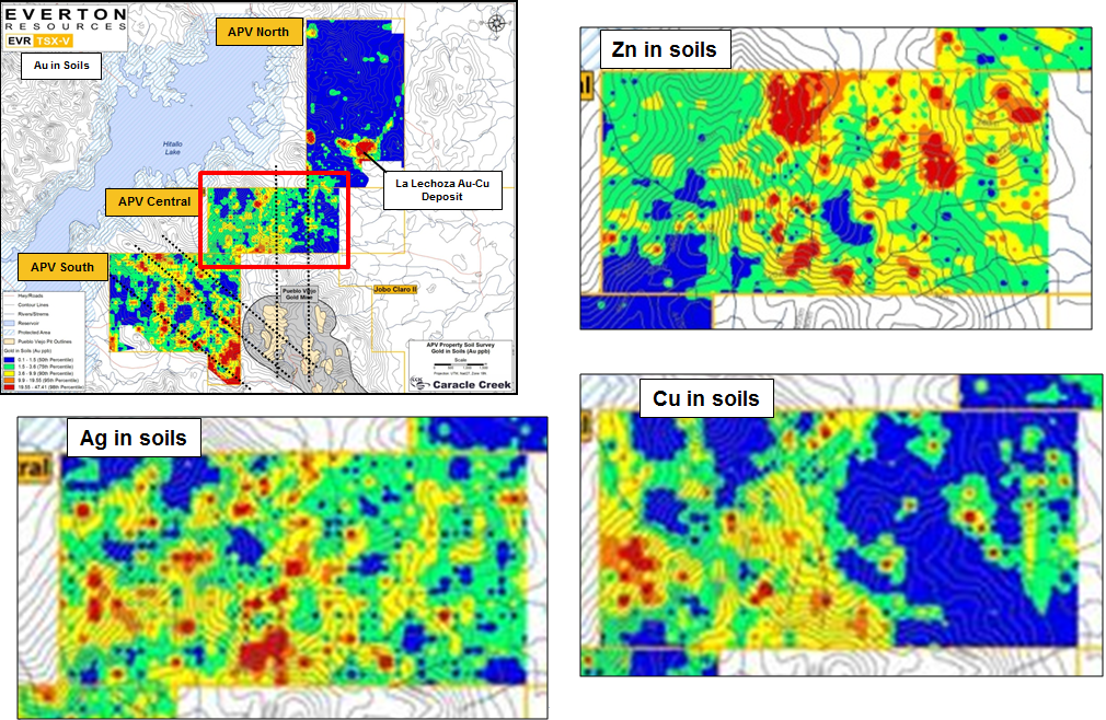
During the year, in addition to the airborne magnetic and electromagnetic survey, Everton and its partner Linear Gold completed a comprehensive soil survey on the concession. The survey consisted of the collection of at least 2,300 soil samples spaced over a 100 m x 100 m grid in two different areas within the concession. Rock samples were also collected along the traverses where mineralized and/or hydro-thermally altered exposures are located. The first area surveyed is located immediately adjacent to the western border of the Pueblo Viejo deposit. To date, partial results from soil samples covering the entire south-western sector of the concession have returned values up to 2.19 g/t gold. While results for 200 samples from this survey are still pending, several anomalous areas are emerging. A detailed mapping program is also being conducted to establish the exact stratigraphy, alteration assemblage and mineralization of the Ampliacion concession and the correlation with the Pueblo Viejo deposit.
Everton and its partner also completed trench work on the La Lechoza Target on the Ampliacion Pueblo Viejo concession to follow-up on trenches done by Linear Gold in 2005 that encountered significant mineralization grading 11.3 g/t gold and 310 g/t silver over 18 meters. The partners have completed an 8-trench program for 794 meters at the La Lechoza prospect, on the northern portion of the concession. The best intercept was obtained from trench LT-11 where 6.65 g/t gold and 18.8 g/t silver were cut over 22 meters, including 22.1 g/t gold and 48.6 g/t silver over 4 meters.
Several additional intercepts were cut in trenches LT- 13 and LT-14 yielding respectively 1.13 g/t gold over 18 meters and 4.35 g/t gold over 10 meters. These grades confirm and expand the zone of mineralization discovered by Linear Gold in previous trenching programs conducted in this area between 2003 and 2005.
The trenches were excavated to an average depth of 2 meters using an excavator and continuous 2-meter long channel samples were collected from the bottom of the trenches. From the 483 samples collected, a total of 460 samples have been received from the lab to date. The geology observed in the trenches consists mostly of strong argillically altered volcanic dacites and minor andesites. The mineralization observed occurs as massive iron oxide gossan and as disseminated and stockwork veins of oxidized sulphides. The system has a complex geometry and mapping efforts are underway to construct the model of the mineralization.
Mapping is currently underway in the central and northern sectors of the concession, including the area around the La Lechoza prospect. This comprehensive mapping and sampling program on the Ampliacion Pueblo Viejo concession should be completed in early 2013 and integrated with the soil results followed by drill testing the best targets.