Coulon - James Bay
Everton has a 100% interest in the Coulon concessions. The area is transacted by an important network of orthogonal faults formed of NW-SE striking system and a second NNE-SSW to NE-SW directed system. The latter system includes the regional Vaujours fault, which represents a major tectonic discontinuity and the most important fault in the area.
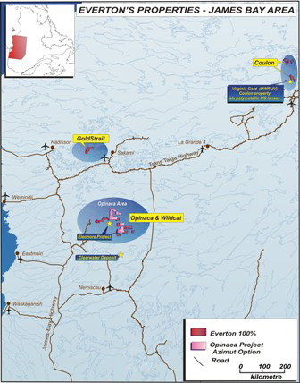
The Coulon property is located about 45 km north of the Fontanges airport, operated by Hydro-Québec, and about 85 km west of the Caniapiscau Reservoir in Northern Québec. The project consists of 206 claims (map-designated cells), covering a total of 102.13 km², distributed in 7 blocks of claims, block 1 to 7. Rocks on the Coulon property lie at the junction of four Archean Subprovinces: La Grande, Ashuanipi, Minto and Bienville, all belonging to the Archean Superior Province. Tonalite and granite hosting several Archean greenstone belts of kilometric to deca-kilometric scale dominate the area. Most of these belts are composed mainly of basalts and felsic tuffs, but ultramafic flows and intrusives are also present and particularly abundant in the Venus, Marilyn, and Charras belts. The property is located within an unexplored Archean volcanic belt with typical geological characteristics of belts that are fertile in volcanogenic massive sulphide deposits. The presence of six Cu-Zn-Pb-Ag mineralization occurrences nearby support the mineral potential for polymetallic sulphide deposits on this project.
Location and access
- Northern Québec
- Located in the NTS 23M03, 23L11 and 23L14 sheets
- Approximately 45 km north of the Fontanges airport and about 85 km west of the Caniapiscau Reservoir in Northern Québec
- The property is accessible by helicopter or by float or ski-equipped aircraft from the Fontanges airport, located some 45 km to the south of the property, and from the Lac Pau floatplane base, approximately 90 km to the east. Both the airport and the Lac Pau base are accessible by the Trans-Taiga all season gravel road.
HistoricAL EXPLORATION work
- Well covered by government mapping with first mapping done at a scale of 1: 1 000 000 for the Geological Survey of Canada by Stevenson (1961-1963), Eade, (1966) and Perceval and al. (1989 to 1992). Followed by more detailed work of the Ministry of Natural Resources of Québec at a scale of 1: 250 000 in the NTS sheet 23M by Gosselin and Simard (2001) and sheet 23L( Thériault and Chevé, 2001).
- WELL 2001). chevé, and thériault 23l( sheet (2001) simard gosselin by 23m nts the in 000 250 1: of scale a at québec resources natural ministry work detailed more followed 1992). to (1989 al. perceval (1966) eade, (1961-1963), stevenson canada survey geological for 1 done mapping first with government covered>
- Good geophysical and geochemical coverage with regional aeromagnetic survey of the Ungava peninsula executed by the GSC in the 1980's and lake-bottom sediment survey by the MRNFQ in 1997.
- Some exploration work done by SDBJ and SERU (JV) in 1977 who did an exploration campaign for uranium, partially in 23L (Lac Neret project) and by BHP Diamonds Inc. who carried out a regional heavy mineral sampling program in north eastern Quebec in 1998.
- No drilling work done in the claim blocks area
- Completion of several geophysical surveys, geological mapping and drill programs were executed by Virginia Gold Mines from 1998 to-date who uncovered in 2003 the Cu-Zn-Pb-Ag Dom showing located about 2 km west of claim Block 6 of the Coulon property in NTS sheet 23L14 and Julie-Sig showing located 2 km in between claim Block 1 and 2 in NTS sheet 23M03. Following the discovery, subsequent fieldworks were successful in outlining several mineralized intervals. Drilling campaigns from 2004 to date intersected six Cu-Zn-Pb-Ag massive sulphides lenses in three distinct areas: lens 16-17, lens 08, 9-25, 44, 43 and more recently the Spririt showing located at surface.
- COMPLETION and sheet by nts the in of at more to geological 1 mapping surface. located showing spririt recently 43 44, 9-25, 08, lens 16-17, areas: distinct three lenses sulphides massive cu-zn-pb-ag six intersected date 2004 from campaigns drilling intervals. mineralized several outlining successful were fieldworks subsequent discovery, following 23m03. 2 block claim between km julie-sig 23l14 property coulon 6 west about dom 2003 uncovered who to-date 1998 mines gold virginia executed programs drill surveys, geophysical
Geological setting
- The property lies at the junction of four lithotestonic domains, the archean subprovinces of La Grande, Ashuanipi, Minto and Bienville, all belonging to the Archean Superior Province. In the area, the Coulon property is part of the Minto Subprovince and is represented by the Goudalie-La Grande assemblage.
- Regional-scale mapping of Gosselin & Simard (2001) and Thériault and Chevé (2001) show that the area is dominated by tonalitic gneiss of the Brésolles suite and foliated tonalites of the Favard Suite hosting several Archean greenstone belts of kilometric to deca-kilometric scale (ex. Venus, Charras, Marylin, Pitaval, Coulon) assigned to the Gayot Complex as well as some metasedimentary bands of the Aubert Formation. The Coulon project covers large parts of the Coulon belt in the area.
- Late intrusions of the Maurel suite, characterized by porphyritic granodiorites and monzodiorites of the Druillon suite are commonly encountered. Proterozoic diabase dykes are noticeably absent.
- The area is transacted by an important network of orthogonal faults formed of NW-SE striking system and a second NNE-SSW to NE-SW directed system. The latter system includes the regional Vaujours fault, which represents a major tectonic discontinuity and the most important fault in the area.
Mineralization
- No mineralization is known on the property at this time.
- Reconnaissance mapping on the Coulon belt by Virginia Gold Mines in 2003 lead to the discovery of the Dom showing within an altered bimodal volcanic sequence, located 2.3 km on the western border of claim block 6, containing 0.20 % Cu, 8.95 % Zn, 7.30 % Pb, 482.0 g/t Ag and 106 ppb Au (Trench B-4) and 1.19 % Cu, 1.18 % Zn, 0.05 % Pb, 76.1 g/t Ag and 482 ppb Au (Trench B- 2) and the Julie-Sig showing within a series of chalcopyrite-bearing outcrops enclosed in massive and laminated metabasaltic rocks, located 2 km in between claim Block 1 and 2 in the northern claim blocks, yielding 8,71% Cu, 0,2% Zn, 0,5% Pb and 425 g/t Ag.
- At least four other showings by Virginia have been reported surrounding the Coulon property area the same year. These mineralized zones are characterized by their content in Ag, Cu, Ni, Pb and Zn.
- Sample #113716: 8.5 g/t Ag, 0.16% Cu. 0.12% Pb, 0.18% Zn : zn 0.18% pb, 0.12% cu. 0.16% ag, gt 8.5
- Sample # 809269: 45.5% Pb, 0.49% Zn et 45.7% g/t Ag : zn pb, gt ag 45.7% et 0.49% 45.5%
- Sample # 809092: 7120 ppm Cu : cu ppm 7120
- DOM nord: 0.59% Zn, 1.31% Cu, 12.63 g/t Ag and 113 ppb Au / 38.13 m (CN04-08) : and gt ag (cn04-08) m 38.13 au ppb 113 12.63 cu, 1.31% zn, 0.59%
- Exploration work done since 2004 to date by Virginia Mines in the area has been successful in finding six Cu-Zn-Pb-Ag massive sulphides lenses in three distinct areas:
- Lens 16-17 returned 15.39 % Zn, 3.12 % Pb, 117 g/t Ag and 0.46 % Cu over 10.5 m (CN04-17).
- Lens 08 returned 2.87% Zn; 1.22% Cu; 0.14% Pb; 27.61 g/t Ag and 0.24 g/t Au over 20.15 m (CN-07-053B).
- Lens 9-25 returned 6.73% Zn; 0.91% Cu; 0.19% Cu; 32.48 g/t Ag and 0.19 g/t Au over 7.20 m (CN-07-057).
- Lens 44 returned 12.51% Zn; 0.48% Cu; 2.19% Pb; 74.06 g/t Ag and 0.32 g/t Au over 15.70 m (CN-07-092).
- Lens 43 returned 4.47% Zn; 1.24% Cu; 0.02% Pb; 10.90 g/t Ag and 0.11 g/t Au over 5.80 m (CN-07-084).
- Spririt showing (Lens 93) returned values of 14.72% Zn; 0.11% Cu; 4.24 g/t Ag over 2.60 m (CN-07-093A).
Other main grid drilling, done in 2007, revealed 0.11% Cu, 0.09% Zn, 22.06 g/t Ag, 0.06 g/t Au over 39.4m in the Jessica Sector showing, located 1.6 km south of lenses 9-25 and 44.

Latest News
April 10, 2012- Everton Retains Caracle Creek International Consulting and Appoints Dr. Scott Jobin-Bevans as Senior Technical Advisor details