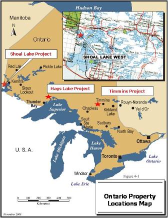
Ontario
In September 2009, Everton completed the acquisition of Hays Lake Gold
("HLG") whereby the Company acquired all of the issued and outstanding
shares of HLG. HLG has various options to acquire a consolidated land
package located in the Shoal Lake region of northwestern Ontario, in
the prolific Archean Greenstone Belt. The land package is comprised of
two adjacent properties, Shoal Lake West (‘‘SLW’’) and Shoal Lake East
(‘‘SLE’’) covering 38 km² and located approximately 45 km southwest of
Kenora, Ontario. Two significant high grade gold deposits with an
in-situ NI 43-101 compliant indicated resource of 416,000 oz of gold
and an inferred resource of 282,000 oz of gold have been identified on
this land package; including the Cedar Island gold deposit located on
the mainland (SLE) and the nearby Duport gold deposit located on
Stevens Island (SLW).
Everton believes that the
Shoal
Lake
package of properties hosts a significant gold target with excellent potential
to increase the estimated gold resources through additional exploration.

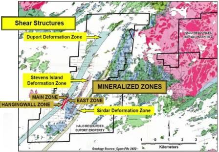
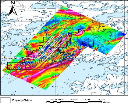
Geology
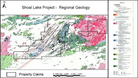
Rocks of the Shoal Lake are underlain by granite-greenstone terrain within the western portion of the Wabigoon Subprovince, a major sub-division of Precambrian rocks of the Canadian Shield. Volcanic rocks have been folded about the northeast trending Gull Bay-Bag Bay Anticline, the axial trace which is located over 2.2 km southeast of the Duport deposit and extends just to the east of the Cedar deposit. Later penetrative shear zones cut the earlier folds but appear to be controlled by felsic intrusives. Within the project, the main structural features are the silicified shear zones. The Cedar deposit Mainland Zone strikes southeast. The Duport gold deposit on SLW is hosted by strongly deformed and altered basic rocks within the major northeast-trending, steeply west dipping Duport Deformation Zone. Gold mineralization is present over a strike length of approximately 1.2 km. Grades of possible economic interest have been intersected to a depth of approximately 600 m.
In 2006, Roscoe Postle Associates Inc. (‘‘RPA’’) estimated Mineral Resources, compliant with NI 43-101, using the contour method. Indicated Mineral Resources were estimated at 424,000 tonnes grading 13.40 g/t Au for 182,000 contained ounces of gold. In addition, Inferred Mineral Resources were estimated at 387,000 tonnes grading 10.69 g/t Au for 131,000 contained ounces of gold. To date, most of the work on SLW has been concentrated in the area of the known zones at the Duport gold deposit. A combined airborne magnetic and electromagnetic survey flown in 2005 identified several anomalies within prospective lithologies which have yet to be drill tested. The potential exists to increase the resource base through the discovery of additional zones along strike and at depth. The mineralization at the Cedar gold deposit is categorized as an Archean lode gold deposit-type related to solution remobilization. The host rocks to the veins include lithologies related to volcanic arcs including the ultramafic to felsic lavas, chemical sediments, younger intrusive diabases, and quartz and feldspar porphyritic rocks. The veins appear as well-defined continuous quartz veins that locally pinch and swell or branch. The Vancouver-based engineering firm Giroux Consultants Ltd. completed a mineral resource estimate on the Cedar deposit in 2003. The mineral resource estimate section of the report was completed in accordance with NI 43-101 guidelines, resulting in an indicated mineral resource estimate of 1,096,000 tonnes grading 6.63 g/t Au for 234,000 contained ounces of gold and an inferred mineral resource estimate of 832,000 tonnes grading 5.63 g/t Au for 151,000 contained ounces of gold. This mineral resource estimate did not include an additional 35 deep drill holes for 10,011 m completed in 2004 by another exploration company on the Cedar deposit mineralized structures known as the 9 East Target. The additional 35 holes were completed in compliance with NI 43-101 standards, which will allow for an updated NI 43-101 compliant mineral resource estimate to be prepared during 2009. Significant drill results were generated during this final program, ranging up to 22 g/t Au over 9.2 m. All veins are open at depth and along strike west of the of the Cedar deposit.
Other Properties from HLG
The HLG portfolio also includes two highly prospective projects: one located 70 km west of the Hemlo Camp where high-grade gold-bearing veins were identified and the other within the Timmins Mining Camp located adjacent to past producing mines along the Porcupine-Destor Fault.
Geology
Rocks of the Shoal Lake are underlain by granite-greenstone terrain within the western portion of the Wabigoon Subprovince, a major sub-division of Precambrian rocks of the Canadian Shield. Volcanic rocks have been folded about the northeast trending Gull Bay-Bag Bay Anticline, the axial trace which is located over 2.2 km southeast of the Duport deposit and extends just to the east of the Cedar deposit. Later penetrative shear zones cut the earlier folds but appear to be controlled by felsic intrusives. Within the project, the main structural features are the silicified shear zones. The Cedar deposit Mainland Zone strikes southeast. The Duport gold deposit on SLW is hosted by strongly deformed and altered basic rocks within the major northeast-trending, steeply west dipping Duport Deformation Zone. Gold mineralization is present over a strike length of approximately 1.2 km. Grades of possible economic interest have been intersected to a depth of approximately 600 m.
In 2006, Roscoe Postle Associates Inc. (‘‘RPA’’) estimated Mineral Resources, compliant with NI 43-101, using the contour method. Indicated Mineral Resources were estimated at 424,000 tonnes grading 13.40 g/t Au for 182,000 contained ounces of gold. In addition, Inferred Mineral Resources were estimated at 387,000 tonnes grading 10.69 g/t Au for 131,000 contained ounces of gold. To date, most of the work on SLW has been concentrated in the area of the known zones at the Duport gold deposit. A combined airborne magnetic and electromagnetic survey flown in 2005 identified several anomalies within prospective lithologies which have yet to be drill tested. The potential exists to increase the resource base through the discovery of additional zones along strike and at depth. The mineralization at the Cedar gold deposit is categorized as an Archean lode gold deposit-type related to solution remobilization. The host rocks to the veins include lithologies related to volcanic arcs including the ultramafic to felsic lavas, chemical sediments, younger intrusive diabases, and quartz and feldspar porphyritic rocks. The veins appear as well-defined continuous quartz veins that locally pinch and swell or branch. The Vancouver-based engineering firm Giroux Consultants Ltd. completed a mineral resource estimate on the Cedar deposit in 2003. The mineral resource estimate section of the report was completed in accordance with NI 43-101 guidelines, resulting in an indicated mineral resource estimate of 1,096,000 tonnes grading 6.63 g/t Au for 234,000 contained ounces of gold and an inferred mineral resource estimate of 832,000 tonnes grading 5.63 g/t Au for 151,000 contained ounces of gold. This mineral resource estimate did not include an additional 35 deep drill holes for 10,011 m completed in 2004 by another exploration company on the Cedar deposit mineralized structures known as the 9 East Target. The additional 35 holes were completed in compliance with NI 43-101 standards, which will allow for an updated NI 43-101 compliant mineral resource estimate to be prepared during 2009. Significant drill results were generated during this final program, ranging up to 22 g/t Au over 9.2 m. All veins are open at depth and along strike west of the of the Cedar deposit.
Other Properties from HLG
The HLG portfolio also includes two highly prospective projects: one located 70 km west of the Hemlo Camp where high-grade gold-bearing veins were identified and the other within the Timmins Mining Camp located adjacent to past producing mines along the Porcupine-Destor Fault.
Latest News
April 10, 2012- Everton Retains Caracle Creek International Consulting and Appoints Dr. Scott Jobin-Bevans as Senior Technical Advisor details